United States Drought
Information
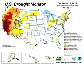
U.S. Seasonal Drought Monitor
 U.S. Monthly Drought Outlook
 U.S. Seasonal Drought Outlook
 North American Drought Monitor

The North American Drought Monitor (NADM) is a cooperative effort between drought experts in Canada, Mexico and the United States to monitor drought across the continent on an ongoing basis. The program was initiated at a three-day workshop in late April 2002 and is part of a larger effort to improve the monitoring of climate extremes on the continent. The NADM (Lawrimore et al. 2002) is based on the highly successful U.S. Drought Monitor (USDM), and as such, is being developed to provide an ongoing comprehensive and integrated assessment of drought throughout all three countries.
Since its inception in 1999, the US Drought Monitor (Svoboda et al. 2002) has been extremely successful in assessing and communicating the state of drought in the US on a weekly basis. As with the US Drought Monitor, the North American Drought Monitor blends science and art. There is no one 'correct' way to measure drought. Drought indices are used to detect and measure droughts, but different indices measure drought in different ways, and no single index works under all circumstances (Heim, 2002). So the Drought Monitor concept was developed (jointly by the National Weather Service, the National Drought Mitigation Center and the US Department of Agriculture's Joint Agricultural Weather Facility in the late 1990s) as a process that synthesizes multiple indices, outlooks and local impacts, into an assessment that best represents current drought conditions. The final outcome of each Drought Monitor is a consensus of federal, state and academic scientists.
Drought monitoring has become an integral part of drought planning, preparedness and mitigation efforts at the national, regional and local levels. Drought can develop in all regions of the continent, and its effects can be devastating. Since 1980, major droughts and heat waves within the U.S. alone have resulted in costs exceeding 100 billion dollars, easily becoming one of the most costly weather-related disasters on the continent during that time (Lott and Ross, 2000).
But in today's global economy the costs and effects of drought often extend beyond international borders.
In 2002, the continuing drought in much of the Southwest U.S. and a prolonged period of drier than normal conditions in Mexico led to debates about shared water rights between the two countries.
And to the north, the multi-year drought in the Northern Rockies and western Great Plains extended well into the agricultural prairies of Canada, greatly affecting agricultural productivity in two countries that provide much of the world's food production.
Although all three countries have active climate and drought monitoring programs, until recently there has been only limited cooperation and coordination between the countries' drought experts. Past drought assessments typically have stopped at each country's borders as differences in resources and policy objectives as well as differing methods for monitoring drought in each country effectively prevented an integrated view of drought conditions across the continent. The NADM program is being designed to overcome these past limitations with the objective of providing operational assessments of drought across the continent later in 2003, when the monthly operational DM maps and discussions will be available to the general public.
NADM Geographical Reference Maps
 Canadian Ecozones
(Provided by Agriculture and Agri-Food Canada)
Canadian Ecozones
(Provided by Agriculture and Agri-Food Canada)

U.S. Crop Areas
(Provided by USDA/Joint Agricultural Weather)

U.S. Geographical Regions
(After Weekly Weather and Crop Bulletin)
Major US participants in the NADM program include NOAA's National Climatic Data Center, NOAA's Climate Prediction Center, the US Department of Agriculture, and the National Drought Mitigation Center. Major participants in Canada and Mexico include Agriculture and Agrifood Canada, the Meteorological Service of Canada, and the National Meteorological Service of Mexico (SMN - Servicio Meteorologico Nacional).