Hurricane Irene Moving Away from Hispaniola
11AM EDT 23 August 2011 Update
Hurricane Warnings are now up for all of the Bahamas. The forecast track shifted very very slightly to the east, but it is mostly an extension of the 5AM official forecast.
Florida is also now out of the cone of uncertainty
Original Update
Hurricane Irene has pulled in a bit of dry air from interaction with Hispaniola that disrupted the inflow a bit overnight, but appears to be on track toward the official forecast path. Outflow is starting to become well defined on the western side of the system, and it appears that it will likely regain and strengthen later today once it moves further away from the Island.
Computer model guidance from last night (with extra data collected from NOAA and Air force planes) has shifted right which implies Florida will see very little impact other than beach erosion and rough surf, which is good news for them (right along the coast may be a little breezy though), however based on the official forecast, a major hurricane is expected to pass 150 miles to the east of Florida, tearing through the central Bahamas. After which it is projected to make landfall in North Carolina near Wilmington late night Saturday into Sunday morning. Most models have come into agreement on it staying east of the US until North Carolina. The track may shift slightly west or east during the day, but should remain relatively in the cone. It is important to note, so far the trends have been to the east.
Beyond the forecast, After that it may rake along the east coast into New England, so folks as far up as Maine into Canada will want to watch Irene.
There are no new watches or warnings so far today.

Satellite shows a slightly disrupted hurricane (from land interaction with Hispaniola), but very little holding it back from regaining and strengthening later after it moves away. Outflow to the north and west of the storm is very conductive for development. There is a slight elongation north to south in the system which would imply a slight tug northward, which is in line with the forecast projections. If anything changes in the near term it would be because of any interesting interactions with Hispaniola. Generally though, Irene is a very large hurricane and field fields are very large so most of the Bahamas will be affected in some way.
Those in Florida will still want to watch it to see exactly how close it gets, but it would have to get within 60 miles of the coast to see any significant hurricane weather from Irene (it is forecast to be 150 miles east near it's closest approach point). And chances of that are low, around 5%, usually not enough to change plans. Chances for Tropical Storm force winds are a little higher right along the Florida east coast at 30% In short, on it's closest approach, you probably won't want to be on the beach. Surfers will get very long period swells as it approaches, but at closest approach it will be too rough to do much.
For those keeping track, the official forecast gets updated at 5AM, 11AM, 5PM and 11PM, with intermediate advisories at 2AM, 8AM, 2PM, and 8PM while watches/warnings are active. In majors, usually updates can come even more often than that. As a note, there is nothing suggesting a shift back to the west will occur right now, if a change would occur, odds are it would be the opposite (to the east).
Those in North Carolina need to use the next few days for preparations, and South Carolina will want to any westward shifts. Those further north into New England will want to watch the progress of Irene as well.
The Bahamas will get a very rough next few days with a major hurricane forecast to be across the heart of the islands.
Active Tropical Systems:
Hurricane Irene
Atlantic Hurricane Season is from June 1 - November 30
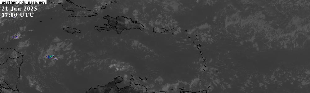
 GOES-13 Satellite - Zoomed in on the Caribbean (14:45 UTC, 54 minutes ago)
Vertical gridlines 10° or about 650 miles (~1050 km) apart.
|
closest point |
advisories |
3/
5 day cone |
models |
image and
loop |
mySat
98L Invest:
satellite images (Navy/NRL) | model track: sfwmd.gov -or-
wunderground.com
90L Invest:
satellite images (Navy/NRL) | model track: sfwmd.gov -or-
wunderground.com
Tuesday, August 23, 2011 08:17AM EDT - 90L
Good morning,
First, thoughts and prayers to those in the T&C and the Bahamas. I hope you are ready.
As I alluded to a couple days ago, while eye's are on Hurricane Irene, we needed to still watch our backside. Here comes now official 90L, located at 12.2N, 19.0W, top winds at 25 mph, 1008 mb pressure and moving west. As it was just classified, not alot of information has been diseminated yet but it is safe to say it appears this will be another one to contend with next week.
And we still have the most active historical period to go!
Dave
 - - click on image for animation - -
The above GOES-13 satellite image is created with the Interactive Weather Satellite Viewer at NASA's Global Hydrology and Climate Center and is updated every 30 minutes (EDT = UTC - 4 hours). The full image is shown at the bottom of this page. Below as well Meteosat Satellite Images of the central Atlantic. These will show waves coming from the African Coast can become the infamous 'Cape Verde storms' or the next big one for the Caribbean islands... Also below, an image of current sea surface temperature. Hurricanes get their energy from warm water. The water usually has to be at least 80F to be able to fuel a hurricane. Is it warm enough yet?
Dave
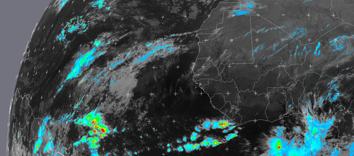
- - Waves from African Coast - -
Below the most recent combined Meteosat-SSM/I MPE (Multi-sensor Precipitation Estimate) and Meteosat Airmass product, focussing on any waves coming off the African coasts. These waves have the potential to develop into hurricanes. Updated every 30 minutes (MPE) or 60 minutes (Airmass). More information on these products on the
EUMETSAT Website. Image Copyright EUMETSAT. For a more detailed view of the African coast a high spatial (but lower temporal) resolution loop can be found on
NASA's NAMMA project website.
- - Precipitation Estimate (MPE) - -

- - Air Mass - -

- - click on images for animation - -
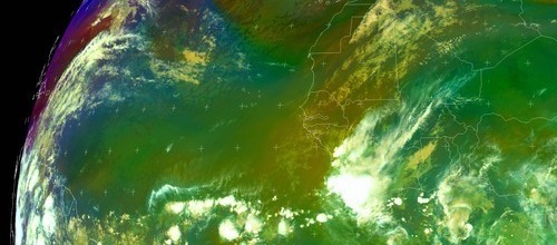
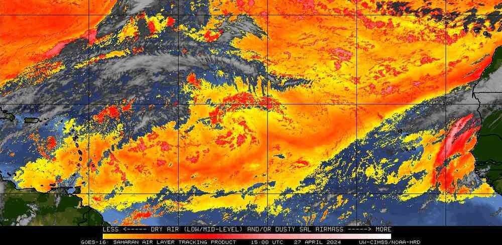
- - Saharan Air Layer (SAL) - -
The Saharan Air Layer (in red below) is a very dry air-mass coming from the African continent. Because it is so dry it can inhibit the formation and/or intensification of tropical storms. See also:
NOAA's Hurricane FAQ. Source original image:
CIMSS at University of Wisconsin-Madison, below my cropped version to accentuate the Atlantic.
- - Saharan Air Layer - -
 - - Click on image for movies and other info - -
- - Tropical Waves - -
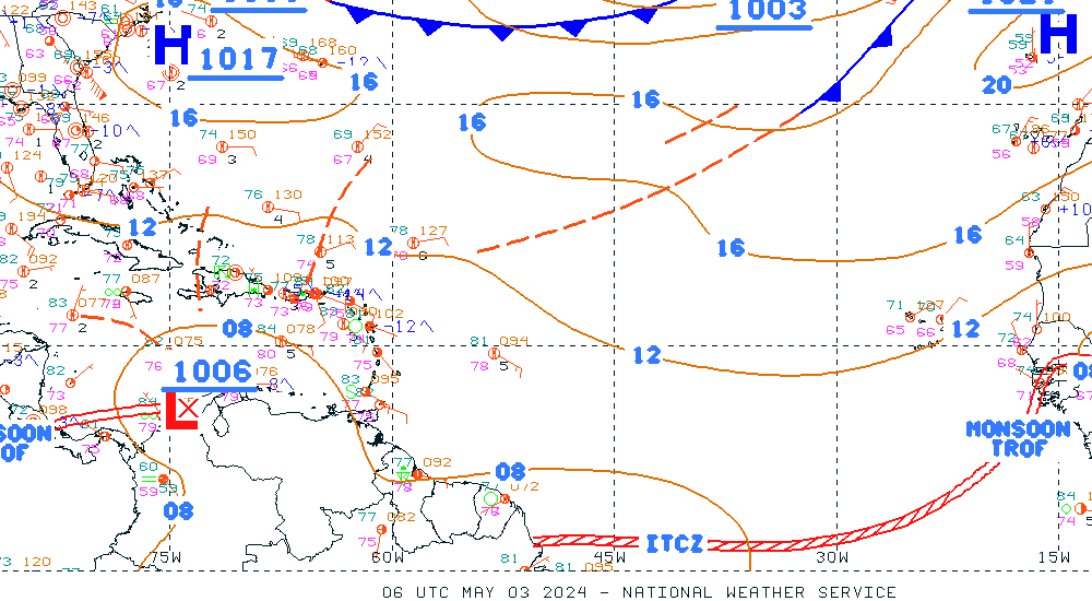
Although not a satellite image, the so-called
Unified Surface Analysis below, shows among other things the location of tropical waves, high/low temperatures, windspeed and direction, the ITCZ, fronts and high and low pressure systems. Comparing it for example to the satellite image below shows how much convection is associated with those waves or low pressure systems. It is produced by the
Ocean Prediction Center (NOAA/NCEP). I cropped the original image, full size can be retrieved by clicking on it.
- - Unified Surface Analysis (NOAA/NCEP) - -
 - - Click on image for full resolution - -
- - GOES-East/Meteosat Combi - -
The two satellite GOES-East and Meteosat cover the Atlantic from different angles. The GOES images are cut off in the Eastern Atlantic, preventing us to see waves coming off the African Coast, while Meteosat doesn't show the Caribbean Islands well. I have not been able to find a nice image combining these two in one, so that we get a clear picture of what is happening in the Atlantic and if something is going to threaten the islands. Therefore I created one myself by combining two
NOAA images using the same type of map-projection. Below you see the GOES-East image on the left and the Meteosat on the right with the split just east of 30W. Note that the times shown below the image can be a bit different and therefore the overlap less perfect (Meteosat gets updated less frequently).
- - More GOES (Central Atl., Caribbean, Gulf+Eastern US) - -
- - GOES Central Atlantic - -
 - - Click on image to see latest loop, + add overlays - -
- - GOES Caribbean - -
 - - Click on image to see latest loop, + add overlays - -
- - G O E S - -
 - - Click on image to create different projections, zoomed images and loops!
Note: Weather satellite data (except SST-map) courtesy of the Global Hydrology and Climate Center in Huntsville Alabama, NOAA/NESDIS and EUMETSAT.